Thursday, June 18, 2020

A few more photos


I didn't have good internet in Petersburg, so I'll post a little something about my trip from Ketchikan to Petersburg now.  I only took a few days, but I went to an area where I hadn't been to before, the Bradfield canal, which is east of Anan Creek Bear Observatory and has a big river that flows into the fjord.  On my way up, I found a lunge feeding humpback whale...  I love how the ventral pleats expand as they gulp.
When I got to the end of the inlet, there was a big tidal flat and the tide was rising, so I got into the canoe and took the tide in.  There was a young brown bear in the grass that watched me approach.
and I got a few nice shots of him before he wandered off.
Another brown bear in the grass never saw me as I drifted past.  The canoe was low down and the grass ended up being about shoulder height, and since the current was going upstream (rising tide still) I could drift along.  There is a hydro power plant there, that gives power to Ketchikan, Wrangell and Petersburg, so the bears probably had seen people plenty and were accustomed to us.
When I got back to the river part, above the high tide area, there were lots of Alders and the sun shone through the clouds for a moment.  I  really like the colors, but of course the photo doesn't do it justice.
There were a lot of beavers back there as well, and they were munching on the alders.  I went about 5 miles back and then took the current back to the boat as the tide dropped.  Its a pretty nice way to explore, but you have to time it right and you can't hurry.  Also, on the trip to Juneau, I got this picture of a loon, but I forgot to post it.  Normally loons in SE alaska are very shy.  At least the "silver headed" ones; the Pacific Loon, the Arctic Loon and the Red-Throated Loon.  I never see them very close, maybe 100 yards at the closest and then they are gone.  The Yellow-Billed Loon as well, it is very shy.  But this one is a Common Loon, and in a river mouth, in shallow water, and it came right over to me and waited.  I have seen this before with loons in lakes in Canada, where fisherman catch trout and then release them, and the loons scoop them up because the fish are tired.  I assume this was the ploy the loon was plying, but I didn't have any tired fish to release.  

Also, on our trip up to the ridge between Windham and Endicott, I took a picture of Mike and I.

Tuesday, June 16, 2020

To Juneau


From Thomas Bay onwards, there were lots of cool things to see, but I'm going to put them all into one post.  We explore the west side of Thomas bay, a place I had never been before, and walked over to Dry Bay, which isn't very deep (as you might have guessed) and dries up at low tide.  It has some great beaver ponds and really nice meadows.  The flowers were out.  We also had some sun on us.
You can see the mountains on the east side of the bay pretty well from there too.
From Thomas Bay we went to Farragut Bay.  People live here, there are lots of cabins in the flat, and we met one resident right off the bat, as he was shirtless and on the beach with no boat.  We anchored and paddled in and learned that he had been trying to get to his fishing boat (a nice seiner) and his kayak had sunk under him and he had to swim to shore.  Since nobody comes in the bay very often, maybe once a week or so, he was lucky to have us find him, about two hours after going for a swim.  The bugs were pretty bad and he was getting eaten, but eaten alive!  I can't imagine swimming more than a very short ways in this water.  We dropped him off at his boat and then went for a paddle up the river, and then over to another cabin with two sailboats sitting in front of it.  There, we met the second resident, who was 80 years old, and had been living there for 40 years.  He was a retired aerospace engineer and had a big plot of land that he was protecting, and told us about how the animals were very friendly.  And then we saw some!  A moose and a bear!  So we went a little closer to look.  I'd like to go back and interview him and film it.  I think people with Uncruise would be interested.
From there we were in Fredrick Sound, which is the province of the Whale.  We saw a few.
And then on to Port Houghton.  I love this bay.  We found a porcupine while waiting for the tide at the narrows to the Salt Chuck, and he was on a log, great for photos.
Here he looks like an old man leaning on a walking stick.  I think he might be a wizard.
In the back bay we found a Black Bear munching on some greens.  It was pretty oblivious to our approach, but finally looked up.
Also I found a Red-Headed Sapsucker, drinking the sap from an alder.  It would run its bill up and down the peeled bark area and collect sap.
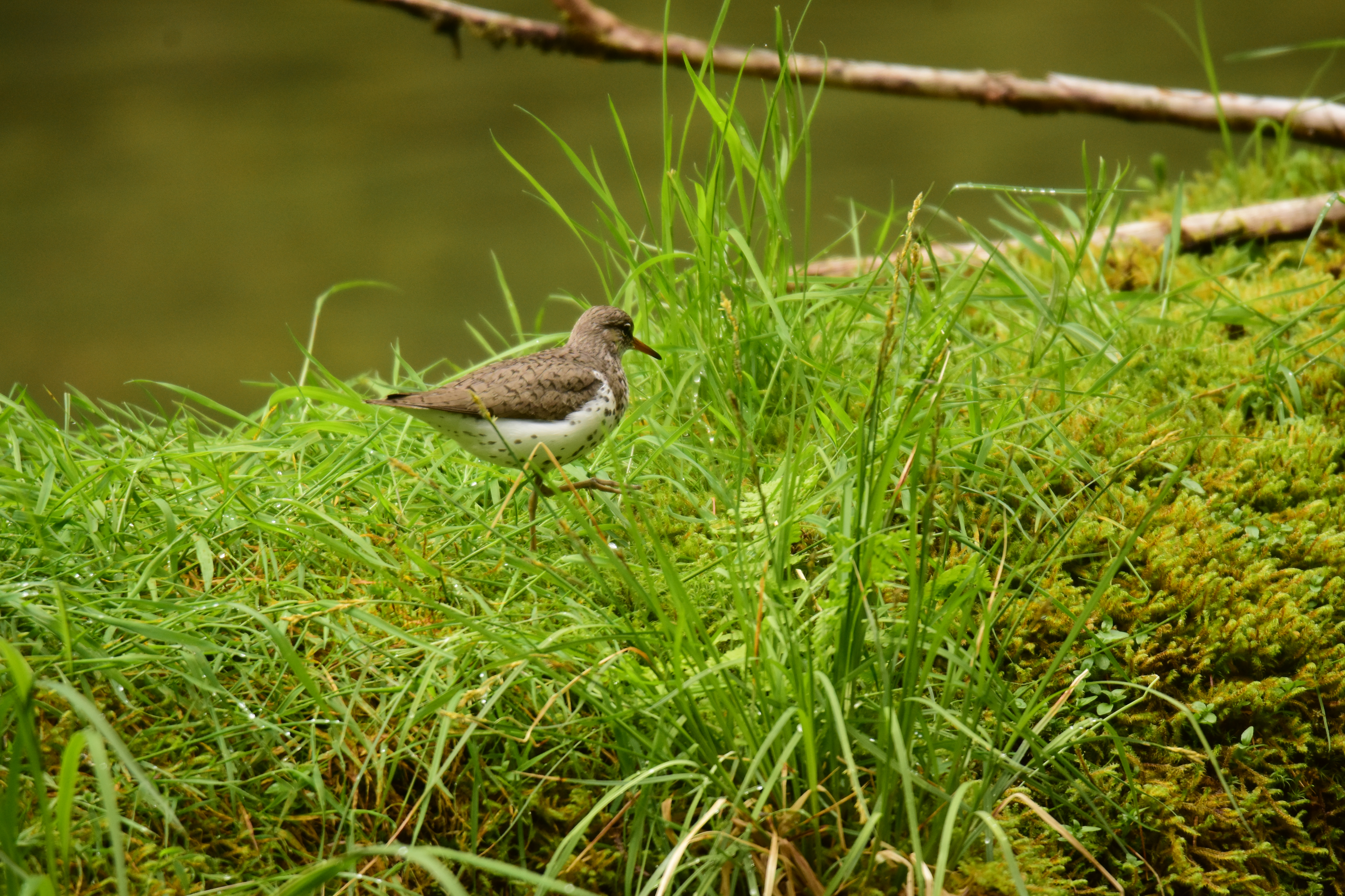
And a Spotted Sandpiper high steeping through the grass on a log up the river.
From there we went to Windham Bay and hiked up the creek to the old mine site.  There are ruins all over there.  
We climbed and climbed, and up about 3 miles and 2400 ft we got to the top of the ridge.  It was pretty terrible brush but when we got above the trees it was nice.
And we could look down on the other side, on Endicott Arm!
The next day we went over to Endicott Arm by boat and found a bear guarding a dead seal on the beach
And a lot of Ice.  So much ice that we couldn't make it more than halfway up the fjord.  But we did make it to Ford's Terror.
In Ford's Terror there are really high cliffs and lots of waterfalls, so we set about looking at them.
This one is in a cleft that you can barely fit the boat into.
I also found a type of fern I had never seen before.  it has a lot of similarities to a Lady Fern, but it also looks like a sword fern, except the leaves are not as dark.  I've never seen it elsewhere.
From Ford's Terror we went to Port Snettisham.  In there we found a lot of Brown Bears.  Many were ok with our approach and we got pretty close.
These two seemed to be about ready to mate.  There was the larger golden one which was a male and the smaller brown one was female, and they touched a few times.  
How do you tell if a bear is male or female?  Its pretty difficult most of the time, but this bear was showing.  Mostly you see which way they pee.  If its forward, its a male, if its back, its female.

Patterson Glacier


After leaving Baird Glacier, we went over to the south side of Thomas Bay and hiked up the Patterson River.  After a 6 mile hike, we found ourselves at the end of the road, and the river kept on going up, but at a slow pace.  We found a canoe hidden in the bushes and borrowed it for the afternoon, and paddled up the river to the lake that is in front of the glacier.  We saw a few mountain goats, shedding their winter coats and looking pretty scraggy.  The glacier doesn't calve into the lake anymore, but sits along a terminal moraine, so we beached the canoe and went for a walk.  I got up on a little hill and took this picture of the weird landscape: the steep angles probably have ice under the dirt and there are muddy lakes and holes in the ground.  It looks like the surface of another planet.
We hiked up a bit further and onto the glacier itself, and there were a lot of patches of moss everywhere.  We looked a bit closer and found that the moss was in small balls: Glacier Mice!
Mostly they stay in groups, but sometimes they are alone.
Further up the blue ice shone through, and meltwater streams flowed down.  
And we found a tunnel
Of course we had to go into it.  It was very wet and drippy in the tunnel, also slick.  But the ice was the most amazing blue color.  
Here's a shot of me in the tunnel.
On our way back out we found a moose and a baby.  We had a bit of time to watch them before they went into the woods.  The baby is all legs!
I had never been up the river that far before and it was a great trip, but we covered 18 miles that day and it took 11 hours.  It rained all day too, so we were soaked and hungry and cold and tired.  And happy.

Baird Glacier


We started our trip out with a bang, when we went to Leconte and ran into some big growlers; (which are large pieces of ice) and after a few hours of trying to get up the fjord we were forced to turn back. It is really pretty up the Leconte Inlet, and we ended up anchoring up there and going for a small hike up a creek that feeds the inlet, but it was just too packed full of ice for Layla to make it up. Instead, we headed north to Thomas Bay! It was raining pretty hard all day and the wind was at our backs (unusual) and we made really good time sailing on up, but it was still pretty late when we arrived in Scenery Cove. On our way in we saw a brown bear with a big piece of machinery. Mike Justa (my companion for this trip) mentioned that it was the typical alaska: "Brown Bears and broken down boats." As we approached to get a closer look at the bear, another bear popped out. It was a black bear with two little cubs. It walked out onto the beach, then looked up and saw the brown bear, and turned right around and boogied out of there. No sense hanging around with something that will eat her cubs.

The next morning we got into the canoe and started paddling over to Baird. Scenery Cove is a few miles away from the outwash plain of Baird Glacier, and so we had to paddle about 4 miles just to get to the river, and since the tide was rising (as we had planned) we were able to catch the rising tide up the river rather than fighting the current. It took us all the way (about 1.5 miles) up the tidal flat and into the "lake" which is the basin that was gouged out by the glacier when it extended further, back in about 2002. In those days, the glacier was pushing its terminal moraine in front of it and created a hill at the top of the outwash plain. Then it began to melt, so waterways have appeared througout the area previously occupied by solid ice. This mechanism is a mystery to me, because I have seen other glaciers that melt and "retreat". They form a vertical face that calves ice off of them and that vertical face is further and further up the inlet every year, because more ice calves off them than the speed of the glacier flow. Sort of like a conveyer belt that is getting chopped up at one end and the choppers are moving up. Baird Glacier is not doing that. I can't really tell what it is doing, but the pieces that we paddled around are enormous. They are hundreds of feet long and wide and I think they are all connected, which would make them thousands of feet long and wide (and maybe hundreds deep). Which means the glacier is just submerged. Since the sea water is pretty warm compared to ice, I would figure the ice would melt, break into pieces, and float, and very soon the lake would have only floating pieces, and then a face would form on the glacier and pieces would calve off. It might take a year to do this. But I've seen this lake with channels in it for the last 4 years. Previous to that, it was much more solid, so no channels. So that means (maybe) that the glacier is moving fast enough to replenish the ice that is melted away, so it doesn't form a face.

It's the only one like this in Southeast Alaska.

So we paddled around the ice a little bit and then walked on the Moraine, and found some Semi-Palmated Plovers.

And we found this moss or something that was beautiful colored and smelled really good.

Here is a picture of us paddling around the ice.

We climbed out and looked at the ice from on the hills over the sides of the glacier, but those hills are polished smooth by the passage of the glacier and we couldn't get very high. Very slippery.

We hauled the canoe out on some of the icebergs and went for a walk.

Here's a shot of Mike looking like John Muir. It was pretty cold so we were wearing the life jackets because the were warm. Also if something happened we could float a bit better, or if we fell they were padding.

Baird Glacier is one of the most interesting places up here to me, since it is really difficult to get to and quite dangerous; there are lots of gigantic forces at work here, with calving ice chunks, rock slides, and currents in really cold water and no place way to climb out on land. With Uncruise, though we came here reasonably often, we barely scratched of exploring this area, and we never had enough time. It changes all the time as well. If I come back this summer it will be completely different. We paddled back to the boat late in the day, and since the tide had fallen, we had a raging river to head down, with icebergs both floating along with us and grounded (with the river making rapids around them). I used a lot of adrenaline in one day. When we got back to the boat we had been out 11 hours.